Showing posts with label Leg 3 : Bangkok to Singapore. Show all posts

Monday, 5 November 2007

Singapore - farewell to Asia

Mark arrived in Singapore this morning and by my calculations must now be only a few miles short of the 9000 miles which are the half way point of his journey. Time constraints for me this evening prevent a longer exploration of Singapore except for one staggering statistic which I unearthed after viewing some of the high res images of the harbour....

There are 15 vessels in this view - most of them container ships. According to the port statistics Singapore receives 1600 container ships a month! Small wonder that it is the largest container port in the world.

And finally, if Mark was unable to get a nice capuccino at Calcutta airport, he should have no similar problems at Changi. The airport has made its mark in the aviation industry as a benchmark for service excellence, winning over 250 awards up to 2006.Certainly, from personal experience, there is not much which you can't buy at Singapore sirport!

Sunday, 4 November 2007

Last stop before Singapore

One of the joys of following Mark's GPS tracker is that some days it leads you to little places you've never heard of and would probably never have reason to know anything about if he hadn't stopped there and fixed his position.
So... welcome to Bahu Pahat at just 1 degree and 51 minutes north of the equator ! In case you are unsure of the divisions of degrees, there are 60 minutes in one degree of latitude or longitude. and the GPs tracker always gives, degrees and minutes to three decimal places. By tomorrow, when Mark reaches Singapore, he will be at the southern extremity of the continent of Asia but will still be one degree short of the equator. He won't cross the equator until he flies out of Singapore bound for Perth.

According to the entry in Wikipedia, Batu Pahat has a population of about 140,000 - hard to imagine when viewed from this altitude! It is a thriving manufacturing city with industries encompassing textiles, electronics, food-processing, timber, porcelain and plastic industry. It produces 50% of the textiles exported from Malaysia and there are about 300 garment and textile factories. A little search on the Internet produced this resource . It's a sort of blog about Batu Pahat but it might on first sight give the impression of being entirely to do with the local gastronomy! Stick with it and you will find some good images of the city and you will certainly be well aquainted with the local delicacies!
A better impression comes from these photos sourced from Flickr...
And how is this for rain .... snapped in January of this year in Batu Pahat... Small wonder that serious flooding followed... Although the Google imagery of Batu Pahat is low res, just to the east of the town there is an area where we can see much more clearly how intensively farmed the surrounding hinterland is.
This is quite a different pattern of land tenure to what we were seeing further north in the areas of extensive plantations. Here, the land seems to be mainly farmed in smallholdings...
It is difficult to be certain what is growing here but there are certainly tree crops other than oil palms. Perhaps, at last, we are seeing some rubber trees! According to Wikipedia the area is also noted for fruit produce such as water-melons, papayas, bananas, pineapples and durians.
And finally, although it's not quite the 5th of November, here are some fireworks in Batu Pahat - the celebration is Malaysian National Day and they are seriously good fireworks....

Saturday, 3 November 2007

Kuala Lumpur and Malacca

By my reckoning, after a day which has taken him through the outskirts of Kuala Lumpur, Mark has stopped for the night at Malacca, some 150 kms from Singapore. For reasons best known to Google, there are no place names in Malaysia on the version of Google Maps in which the GPS tracker is fixed. After the difficulties of the Thai alphabet, I am still still having to cross reference with an atlas so I hope I am right!

Mark reached Kuala Lumpur , the capital and largest city in Malaysia, long before any of us the UK would have been awake. The link to Wikipedia produces a huge amount of detail on the history and current economic boom of the city. The landmark building of KL which is rapidly becoming an iconic image for the city is the Petronas Twin Towers which were, until 2004, the tallest building in the world. here is how they are portrayed on Google earth with the 3D building layer active.... Although Mark did not cycle through the city centre, it is hard to imagine that he would have missed the towers seen here in one of the embedded photos.. And here, the view from the sky bridge, over the ultra modern business quarter of the city.....
Sometimes when I'm browsing the Google images along Mark's route, I come across little details which fascinate.... like this six lane highway and toll plaza. You can look at a view like this and be almost anywhere in the world. Ask yourself, if you didn't know it was KL, where might you think it was? From KL, it took Mark another 6 hours to reach Malacca which is described by Wikitravel as 'a sleepy city that belies its wealth of history'. It seems that Dutch, Portuguese asnd British involvement have all left their mark on the city, not least in the architecture....

Friday, 2 November 2007

Padis, plantations and..... snow!

First.... Mark's weather report for the last couple of days is exactly what I teach when I'm doing equatorial climates.....
More monsoon rain and very humid. Also hot sun in between the downpours and sunburned for the first time since Turkey.

Day started dry but then the great cloud bursts started and created 3 inches of water on the road making cycling very difficult.
At three degrees north of the equator, the tropical wet and dry season regime of India and Thailand has given way to the more equatorial pattern of rain at all seasons! No comfort for Mark but very reassuring for me to know that the textbooks are right!

One of the features of rainfall at the equator is the typical daily pattern of clouds building up during the day leading to downpours in the afternoon. The graph above is for Kuala Lumpur, just south of where Mark is today and shows the average percentage of rain falling at different times of the day. 4pm is clearly when you need to have a brolly ready!

Today Mark has been cycling through some hilly terrain and must have been enjoying lovely views of padis and plantations, forests and land newly cleared and planted. This view is typical of the landscape he has been passing through today....
.....and close up, there is some lovely detail of flooded rice fields with their surrounding low mud walls called 'bunds'. To the right of the image are the serried ranks of oil palms we've become familiar with in the last couple of days.
As for the snow.... I'll bet Mark would have enjoyed a wee detour this evening. Does he even know that up in the hills surrounded by rainforest and just a few miles east of where he is staying tonight is the vast Genting Highland Resort? Now, believe me, if you only check out one link on tonight's posting, make it this one! You will not be disappointed. I have just explored every page of this website and I am speechless... that doesn't often happen to me.

Thursday, 1 November 2007

Rainforests... I'm loving them!

If there is one topic which fires the imagination of pupils in the geography classroom, it has to be rainforests. From their primary school forays into a world of giant trees, strange creepy crawlies, amazing animals and fascinating cultures to their more politically correct studies of deforestation and conflict with indigenous peoples in senior school, rainforests are always high on their list of favourite topics. Today as Mark has headed inland through a low and thickly forested mountain range, I have been exploring the 'jungle' and loving it! Here is a patch of rainforest about ten miles from the road he was cycling on this morning......Rainforests cover about about 47% of Malaysia but are disappearing at the rate of 2.4% annually. I have found some excellent images of the Malaysian rainforest which you can access by clicking on the image below.
A simple search for 'Malaysian rainforest' in Google will also produce countless links for you to read if you are interested in the subject.

However, in the area of rainforest which Mark was passing close to this morning, there is also graphic evidence of why the rainforest is disappearing...
...rainforest top right, tin mining in the centre and oil palms encroaching from the left!

According to the GPS tracker, Mark is over-nighting today near Ipoh which, according to Wikipedia carries the nicknames of "City of Millionaires" and "the Town that tin built"; referring to the vast fortunes made during the boom of the tin mining and rubber industries. However, it seems that it is also something of a large retirement complex! With the collapse of tin prices and the closure of the tin mines in the late 1970s, Ipoh's growth had stagnated and resulted in the migration of many young talents to other parts of Malaysia Ipoh has since been known colloquially as a "dead" city and earned a reputation as a good location for retirement.

And finally, one of the reasons why the rainforest should be preserved.... the rarest, smelliest, flower in the world. The commentary is not easy to make out but there are some excellent views of the rainforest in north west Malaysia and the amazing Rafflesia flower.

Tuesday, 30 October 2007

Well into Malaysia

Mark crossed from Thailand to Malaysia yesterday and has already reached the city of George town, capital of the island and state of Penang. After several days of following Mark's journey down through Thailand, it is probably now useful to draw back a bit and take a look at Malaysia within the broader context of SE Asia...Malaysia comprises two main areas of land - the Malay peninsula (Western Malaysia) which forms the southern extremity of the continent of Asia plus Malaysian Borneo (East Malaysia) which occupies one third of the island of Borneo. To the south of Malaysia lie the islands of Indonesia, the largest of which (Sumatra) is separated from Malaysia by the narrow Straits of Malacca. This stretch of water is often held to be the most important shipping lane in the world forming the main passage between the Indian and Pacific Oceans. At its narrowest, beside Singapore, it is only 2.5 kms wide. The position of Malaysia, commanding trade routes between India and China, meant that it saw a sequence of colonial rulers (Portuguese, Dutch and British) before gaining independence in 1957. The details of Malaysia's history are well described here.

In terms of relief......the Malay peninsula comprises a series of coastal plains rising to often densely forested hills and mountains. As the map shows, the highest land is a narrow mountain spine about 2000m high in the north and west of the country.

Today Mark has cycled south through the province of Kedah. The web diary reveals that it is still raining and, as explained a couple of days ago in this posting , there is unlikely to be much change! If anything, November will get wetter. Certainly the BBC weather pages suggest rain for the next five days for Penang and by then, of course, Mark will be heading for Australia and back to semi desert conditions.!

Kedah is known as the rice bowl of Malaysia and it produces about one third of the country's total production of the crop. Following Mark's route today, there were several places with good views of flooded rice fields..

Most of the Google images in Thailand and Malaysia have clearly been taken in the dry season when there is less cloud cover. This means that the fields are bare, the rice having been harvested. However, next to rivers, as in this image, it will be possible to irrigate in the dry season and therefore obtain a second crop of rice in the year.

Away from the padis there are mile upon mile of plantations.. Although rubber used to be the main plantation crop of Malaysia, these are more likely to be oil palms . And there's a lot of them !


Tonight Mark is over-nighting in Butterworth, the city on the mainland which is joined to the island of Penang and the city of Georgetown by the 13km long Penang bridge for which there is some excellent high resolution imagery...

...and a nice photo from Flickr

Thailand - over so soon!

I'm still getting used to the time difference on the GPS tracker. I looked at the map today and had visions of Mark cycling in the middle of the night....However, given the 7 hour difference, it was not so early after all! From the air, the most striking feature in this part of southern Thailand is the 100km long lagoon complex on the east coast. A bit of Internet research revealed that it is called Thale Luang (sometimes Lake Songhkla) and it is the largest natural lake in Thailand. There is a good account of it here which includes reference to a small population of river dolphins in the lake which are threatened by the amount of fishing which takes place. Flickr obliged with a photo!
As explained on his web diary, Mark's original intended route into Malaysia through the extreme south east of Thailand is unadvisable due to insurgency (The International Herald Tribune website explains the details of this) and thus he will now be crossing sooner into Malaysia and following the west coast route to Singapore. 13 countries down............

Monday, 29 October 2007

It's the monsoon season in Thailand!

I have just read the latest postings on Mark's web diary.....
'rain this morning and for most of the day'
'torrential monsoon rain all afternoon - rain like Mark has never experienced before' .
Cue some chat about tropical rain, I think!

Firstly, tropical rain tends to be much more intense than the rain we experience in temperate latitudes. The main reason is that it is related to convection activity associated with heating of the earth's surface. Secondly, although there is rain at all seasons, there is generally one part of the year (known as the wet season) when rainfall amounts are much more than during the rest of the year. The climate data for Songkhla in the south of Thailand illustrates the pattern well...
The abrupt change in total precipitation from month to month is another common feature of tropical climates. While temperatures only vary by a degree of two throughout the year, rainfall amounts vary enormously. Here, for example, in the south of Thailand, the rainfall in January is one fifth of the December total. The reason is related to shifting wind belts which can very swiftly swing from one direction to another bringing warm, moisture laden air from surrounding seas and oceans for part of the year and carrying it away for the remainder.

Unfortunately, Thailand is right in the middle of the wet season just now and if anything, it looks like it is about to get wetter! However, with luck, Mark should be in Australia by the time the worst of the rains hit Thailand.

In common with many Tropical countries, the annual rainfall regime dictates the annual agricultural cycle in Thailand. Although there is some irrigation fed cultivation, most of the farming is rain-fed wet season rice cultivation. Fields are prepared in August, planted in October and the rice is harvested in February. The fields then lie empty awaiting the arrival of the next rainy season. The image below shows rice fields in the dry season just to the south east of where Mark was cycling today (in one of the rare areas of high res coverage in Thailand)...

And here is an idea of what that rain Mark describes might be like (filmed in Penang, Malaysia)..

Sunday, 28 October 2007

When does it get dark in Thailand?

On the day when we have put the clocks back and entered our five months of very short daylight hours, I thought it might be worth 'visiting' the subject of daylight in the tropics.

Today Mark's GPS tracker was showing him at approximately 9 degrees north of the equator. Equatorial regions have a very different daylight and darkness regime to that of higher latitudes. Firstly, there is very little difference between daylight and darkness hours throughout the year and secondly, dawn and dusk are much shorter i.e. it becomes light or dark much faster. Regions at the equator can expect 12 hours of daylight and 12 hours of darkness all year round. At 9 degrees north, there will only ever be a very little difference between daylight and darkness hours and at present (between the autumn equinox and the winter solstice in the northern hemisphere) it will amount to about an hour more darkness that daylight. However, there is an easy way of finding out whether it is dark in Thailand - or anywhere else for that matter !

If you click on the map above (for 19.22 GMT), it will link you to a website which gives you the answer.

Thai time

Welcome to new readers to the Geo Blog - I am hoping some of you are delegates from the Scottish Association of Geography Teachers conference who attended my presentation on blogging yesterday!

The GPS tracker is now making it seem as if Mark is up with the nightingale but we have to remember that we have 'gone back' to GMT and Mark is now 7 hours ahead....
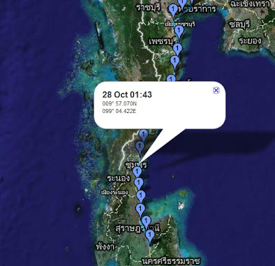
As I post to the blog, Mark has doubtless finished for the day and is now somewhere 30-40 miles south of Surat Thani in the province which carries that name. Remember that if you are having difficulty with the Thai alphabet, either use an atlas or switch to Google Earth to get place names in a recognisable format!

Although the name Surat Thani will be unfamiliar to most of us, the province is the location of the much better known Ko Samui (the southernmost of the two small islands shown in red off the east coast on this map).
In recent weeks another location in this province also hit headlines around the world when a number of tourists were drowned in a limestone cave in the Khao Sok national park which is in the hills in the west of the province.

Earlier today Mark skirted the town of Surat Thani which is located in the angle of the bay on the east coast and cycled close to one of the few areas in this part of Thailand which benefits from high resolution Google imagery revealing a river delta with some interesting patterns of cultivation.....
This is clearly showing a plantation crop but what is it? A bit of research produced the fact that the main agricultural product of the province is coconut so I guess that is what we are looking at in this view. The conditions for coconut also match closely what is found in this part of Thailand... "The coconut palm thrives on sandy soils and is highly tolerant of salinity. It prefers areas with abundant sunlight and regular rainfall (1,500 to 2,500 mm annually), which makes colonizing shorelines of the tropics relatively straightforward. Coconuts also need high humidity (70–80%+) for optimum growth"
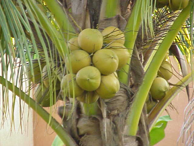
Wikipedia also produces the following about coconut production in Surat Thani... "The coconuts are often picked from the tree by specially trained monkeys, The monkey school of late Somporn Saekow (who lived in Surat Thani) is the most famous training center for these monkeys. " As I said a couple of days ago, you learn something new every day!

Mark's last logged position today places him close to a large reservoir for which some high res Google data is available..


Fish farming perhaps?
Finally, I received a nice, 'geographical' text message from Mark this morning... frequent rain and humid. Lovely mangrove forests, plains and mountains. Looks like Jurassic Park!

Friday, 26 October 2007

Kra Isthmus

You learn something new every day and today's new knowledge for me is the name of the isthmus which joins SE Asia to Malaysia. The eastern side of the Kra Isthmus along which Mark has been cycling today is a narrow coastal plain onto which most of the population in the area is crowded. 10 -15 miles inland, the flat terrain gives way to a mountainous spine which is covered in dense tropical rainforest.....In the view above, you can clearly see a large lake in the middle of the image. This is the Kaeng Krachan Dam. Completed in 1996, it is 58 metres high and 760 metres long, overlooking beautiful scenery of the reservoir and its islands...The reservoir is on the edge of Thailand's largest national park - the Kaeng Krachan National Park. The hyperlink links to a detailed website about the park with 'interesting' English but also a gallery of lovely photos. Sadly, forest fires, mostly started deliberately to clear land, are common in the dry season in this part of Thailand and it doesn't take long to find some examples in the forests round here close to the Burmese border..By lunchtime today Mark was approaching the narrowest part of Thailand - a mere 15km wide between the Gulf of Thailand and the Burmese border...
There are some lovely beaches along the coast here which sadly Mark will not be able to visit. The race must go on!