Showing posts with label Thailand. Show all posts

Tuesday, 30 October 2007

Thailand - over so soon!

I'm still getting used to the time difference on the GPS tracker. I looked at the map today and had visions of Mark cycling in the middle of the night....However, given the 7 hour difference, it was not so early after all! From the air, the most striking feature in this part of southern Thailand is the 100km long lagoon complex on the east coast. A bit of Internet research revealed that it is called Thale Luang (sometimes Lake Songhkla) and it is the largest natural lake in Thailand. There is a good account of it here which includes reference to a small population of river dolphins in the lake which are threatened by the amount of fishing which takes place. Flickr obliged with a photo!
As explained on his web diary, Mark's original intended route into Malaysia through the extreme south east of Thailand is unadvisable due to insurgency (The International Herald Tribune website explains the details of this) and thus he will now be crossing sooner into Malaysia and following the west coast route to Singapore. 13 countries down............

Monday, 29 October 2007

It's the monsoon season in Thailand!

I have just read the latest postings on Mark's web diary.....
'rain this morning and for most of the day'
'torrential monsoon rain all afternoon - rain like Mark has never experienced before' .
Cue some chat about tropical rain, I think!

Firstly, tropical rain tends to be much more intense than the rain we experience in temperate latitudes. The main reason is that it is related to convection activity associated with heating of the earth's surface. Secondly, although there is rain at all seasons, there is generally one part of the year (known as the wet season) when rainfall amounts are much more than during the rest of the year. The climate data for Songkhla in the south of Thailand illustrates the pattern well...
The abrupt change in total precipitation from month to month is another common feature of tropical climates. While temperatures only vary by a degree of two throughout the year, rainfall amounts vary enormously. Here, for example, in the south of Thailand, the rainfall in January is one fifth of the December total. The reason is related to shifting wind belts which can very swiftly swing from one direction to another bringing warm, moisture laden air from surrounding seas and oceans for part of the year and carrying it away for the remainder.

Unfortunately, Thailand is right in the middle of the wet season just now and if anything, it looks like it is about to get wetter! However, with luck, Mark should be in Australia by the time the worst of the rains hit Thailand.

In common with many Tropical countries, the annual rainfall regime dictates the annual agricultural cycle in Thailand. Although there is some irrigation fed cultivation, most of the farming is rain-fed wet season rice cultivation. Fields are prepared in August, planted in October and the rice is harvested in February. The fields then lie empty awaiting the arrival of the next rainy season. The image below shows rice fields in the dry season just to the south east of where Mark was cycling today (in one of the rare areas of high res coverage in Thailand)...

And here is an idea of what that rain Mark describes might be like (filmed in Penang, Malaysia)..

Sunday, 28 October 2007

When does it get dark in Thailand?

On the day when we have put the clocks back and entered our five months of very short daylight hours, I thought it might be worth 'visiting' the subject of daylight in the tropics.

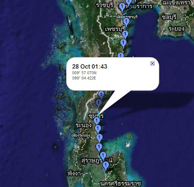
Today Mark's GPS tracker was showing him at approximately 9 degrees north of the equator. Equatorial regions have a very different daylight and darkness regime to that of higher latitudes. Firstly, there is very little difference between daylight and darkness hours throughout the year and secondly, dawn and dusk are much shorter i.e. it becomes light or dark much faster. Regions at the equator can expect 12 hours of daylight and 12 hours of darkness all year round. At 9 degrees north, there will only ever be a very little difference between daylight and darkness hours and at present (between the autumn equinox and the winter solstice in the northern hemisphere) it will amount to about an hour more darkness that daylight. However, there is an easy way of finding out whether it is dark in Thailand - or anywhere else for that matter !

If you click on the map above (for 19.22 GMT), it will link you to a website which gives you the answer.

Thai time

Welcome to new readers to the Geo Blog - I am hoping some of you are delegates from the Scottish Association of Geography Teachers conference who attended my presentation on blogging yesterday!

The GPS tracker is now making it seem as if Mark is up with the nightingale but we have to remember that we have 'gone back' to GMT and Mark is now 7 hours ahead....
As I post to the blog, Mark has doubtless finished for the day and is now somewhere 30-40 miles south of Surat Thani in the province which carries that name. Remember that if you are having difficulty with the Thai alphabet, either use an atlas or switch to Google Earth to get place names in a recognisable format!

Although the name Surat Thani will be unfamiliar to most of us, the province is the location of the much better known Ko Samui (the southernmost of the two small islands shown in red off the east coast on this map).
In recent weeks another location in this province also hit headlines around the world when a number of tourists were drowned in a limestone cave in the Khao Sok national park which is in the hills in the west of the province.

Earlier today Mark skirted the town of Surat Thani which is located in the angle of the bay on the east coast and cycled close to one of the few areas in this part of Thailand which benefits from high resolution Google imagery revealing a river delta with some interesting patterns of cultivation.....
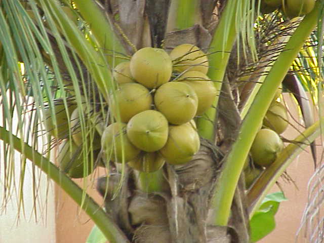
This is clearly showing a plantation crop but what is it? A bit of research produced the fact that the main agricultural product of the province is coconut so I guess that is what we are looking at in this view. The conditions for coconut also match closely what is found in this part of Thailand... "The coconut palm thrives on sandy soils and is highly tolerant of salinity. It prefers areas with abundant sunlight and regular rainfall (1,500 to 2,500 mm annually), which makes colonizing shorelines of the tropics relatively straightforward. Coconuts also need high humidity (70–80%+) for optimum growth"

Wikipedia also produces the following about coconut production in Surat Thani... "The coconuts are often picked from the tree by specially trained monkeys, The monkey school of late Somporn Saekow (who lived in Surat Thani) is the most famous training center for these monkeys. " As I said a couple of days ago, you learn something new every day!

Mark's last logged position today places him close to a large reservoir for which some high res Google data is available..


Fish farming perhaps?
Finally, I received a nice, 'geographical' text message from Mark this morning... frequent rain and humid. Lovely mangrove forests, plains and mountains. Looks like Jurassic Park!

Friday, 26 October 2007

Kra Isthmus

You learn something new every day and today's new knowledge for me is the name of the isthmus which joins SE Asia to Malaysia. The eastern side of the Kra Isthmus along which Mark has been cycling today is a narrow coastal plain onto which most of the population in the area is crowded. 10 -15 miles inland, the flat terrain gives way to a mountainous spine which is covered in dense tropical rainforest.....In the view above, you can clearly see a large lake in the middle of the image. This is the Kaeng Krachan Dam. Completed in 1996, it is 58 metres high and 760 metres long, overlooking beautiful scenery of the reservoir and its islands...The reservoir is on the edge of Thailand's largest national park - the Kaeng Krachan National Park. The hyperlink links to a detailed website about the park with 'interesting' English but also a gallery of lovely photos. Sadly, forest fires, mostly started deliberately to clear land, are common in the dry season in this part of Thailand and it doesn't take long to find some examples in the forests round here close to the Burmese border..By lunchtime today Mark was approaching the narrowest part of Thailand - a mere 15km wide between the Gulf of Thailand and the Burmese border...
There are some lovely beaches along the coast here which sadly Mark will not be able to visit. The race must go on!

Thursday, 25 October 2007

Welcome to the Geography of Thailand

It was wonderful to log into the tracker earlier and find that leg 3 is under way...The first problem for those of us who are following the tracker is that place names in Thailand on Google Maps would appear to be written in the Thai alphabet . I may, therefore, have to cross reference with Google Earth as the place names there appear to be in 'English'.... and there is the added benefit, as explained in this posting, of extra layers of information including some excellent photos. Let's hope that road signs in Thailand are at least partly written in the Roman alphabet and easier to understand! The second problem is that the area with high resolution imagery seems to be more limited than in India and Pakistan.

I think Thailand is in the time zone which is GMT plus 7 hours but for the next three days until we change our clocks, Mark will be 6 hours ahead of us.

As we embark on our geographical learning journey through Thailand, it is probably useful to set the scene with a map which sets the country in its context within SE Asia. As Mark has flown into Bangkok and will be cycling down the connecting isthmus towards Malaysia from there, he will only be travelling through the southern part of the country. As the map shows, most of the land area of Thailand is to the north of Bangkok. The isthmus which joins Malaysia to SE Asia is shared in its northern part by both Burma and Thailand. In fact, the first part of Leg 3 takes Mark to a point within 30km of the Burmese border before entering the southern part of Thailand which has a coast on the Indian Ocean (Andaman Sea) and the Gulf of Thailand.

The relief map shows that the Burmese/Thai border follows the mountain spine in the centre of the isthmus and as Mark's route will take him along the coastal lowlands to the east of that, there should be none of the arduous climbs he encountered in leg 2. There will, of course, be other difficulties such as much higher humidity and its attendant problems.
Shortly after leaving Bangkok airport, Mark was cycling south close to the coast through an area with linear land use patterns... it was difficult to decide exactly what they represented until a look at a similar area with high res imagery produced evidence that they are rice fields with various degrees of flooding...
A little further on, Mark crossed a river which flows out into the Gulf of Thailand. Just a few miles upstream is the location of the fabled Bridge over the River Kwai....

P.S. have just read yesterday's web diary. I am sorry to hear Mark had such a traumatic experience at Calcutta airport but immensely glad he and Ted bear made it through - even if they didn't quite manage that cappucino in departures!