 Spatial distribution is a theme which appears in almost every definition of the scope of the geography and so it has been interesting for me to watch how the patterns on the cluster map on the blog have evolved over the last few months. It is clearly not a random distribution! The coincidence with Mark's route is striking but there are other factors at play as well. English speakers predominate and population density and distribution are also playing a part - hence India's 1 billion+ population are well represented throughout the country while over in Australia (apart from the solitary dot at Alice Springs) most of the readership are on the coastal fringe. Likewise in Canada, those reading the blog are primarily in the cities in the south of the country - apart from my reader or readers in Churchill on Hudson Bay. The geographer in me is fascinated by all of this. So please feel free to add comments to the blog - wherever you are (always bearing in mind that I do retain the option to moderate!) .
 Over in Texas there has been a noticeable difference in the land use of the terrain Mark has been cycling through. Yesterday he was still in what the Texans refer to as 'hill country' but the climate is slowly changing as he enters the 'mid green', more humid centre and east of the state. Austin, just a little east of his position yesterday, receives an annual total of 800mm making it as wet as Dundee in Scotland where this blog is being written. However, and it is a big however, that rainfall is not evenly distributed. The driest time of the year coincides with the highest temperatures and at other times when there is more ample rainfall, temperatures are high enough to cause a big loss through evapotranspiration. Then there are the years, common in sun tropical areas of the world, when the rains fail and there are problems of severe drought. It is worth remembering that Texas (though not the main state to be affected)was one of the Dust Bowl states back in the 1930s when a prolonged drought and severe winds brought misery to so many farmers in America's mid west.
 Thus it is not surprising to find significant evidence of irrigation and soil conservation practices along this section of Mark's route. Here(right) is some pivot irrigation just west of Mason where Mark commenced his route yesterday and below two areas near Stonewall which he passed later in the day which are representative of the wide areas of contour ploughing evident in this part of Texas. We have encountered this form of soil conservation before along the route of Mark's journey as described here in Australia.
 The insufficiency and unreliability of rainfall dictates that farming in this part of Texas is remains mainly pastoral - cultivation is often to produce fodder crops for cattle, sheep and quite a large number of mohair producing goats. There is some interesting information about Texan farm produce available here. Amongst other statistics, it reveals that Texas is the number one state in the US for the production of cattle, sheep, mohair and hay.
Mark's route yesterday took him through undulating and extensively farmed hill country and through valleys with increasing signs of cultivation and more habitation than had been evident on the higher, drier land further west......places like Fredericksburg below which acquired its German name from the fact that it was settled by German immigrants to Texas in the 1840s It is , according to Wikipedia, "notable as the home of Texas German, a dialect spoken by the first generations of settlers who refused to own slaves and were an important part of the Pro-Union Texas resistance during the Civil War, facing ostracization from their slaveholding neighbours. "
 Fredericksburg's other claim to fame is more geological than cultural and relates to its location just a few miles south of this rock feature known as a bathlolith whose origins are similar to the mighty Uluru (Ayers Rock) in Australia. It is called Enchanted Rock and represents the summit of a huge dome of granite which once lay deep within the crust and which has been slowly revealed by erosion of the overlying sedimentary rocks. Had Mark known to look out for it as he headed towards Fredericksburg, he would certainly have spotted it as it is a visible feature from miles around.
One of the agricultural legacies of the early German settlers to the area was viticulture and , as the map shows, Fredericksburg is the centre of an extensive area of grape production in central Texas. The area shaded in pink is described as the "Texas Hill Country Viticultural Area" . A description of a typical winery in the region are here. I'd never have associated Texas with viticulture but you learn something new every day!

Having reached Fredericksburg, the route yesterday took Mark east along the valley of the Pedernales river to Johnson 'City' and south to Blanco...... ... he passed Stonewall, birthplace of Lyndon Johnson...
  ....and Johnson City itself named after one of Johnson's predecessors who founded the town in the 19th century. Just west of the town is the LBJ National Historical Park which commemorates the life of the 36th American president and preserves the ranch where he lived for most of his life and is buried.
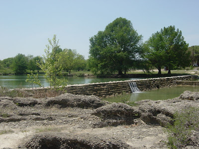
 By the end of the day Mark had reached Blanco on the Blanco River.
Like many of the rivers in this part of Texas the Blanco river has a very variable regime (dictated by climate and the permeability of the rocks in its basin). many weirs have been constructed across the river and here at Blanco itself the weirs combine to create a recreational area which has been designated a state park.


No comments:
Post a Comment