 The aerial view shows Mark heading south from Yazd with some high terrain to his west. I happened to look at the atlas and saw that this high terrain is in fact a mountain peak called Shir Kuh
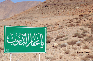
  which rises to over 4000 metres. This will be the sort of view which Mark has had this morning (though probably with less snow on it). This photo of the mountain is again from the galleries of Brian McMorrow which I discovered yesterday as a source of lovely images of the region. Here is another which illustrates the difficulty of reading road signs in Iran .....
I have also finally found a good relief map of Iran - in German but it serves the purpose...

There is not a lot of low, flat land in Iran! Having cycled along the grain of the Elburz mountains in the north, Mark is now following the Zagros mountains in the west.


1 comment:
I'm learning a lot about Iran from your google earth/google search commentary. Very informing!
I've forwarded your blogspot URL to my sons teacher in Jackson, MI USA.
Keep up the fantastic work!
Post a Comment