 When Mark crossed the NSW/Queensland border at Goondiwindi earlier today, he was crossing into the fifth state of his journey through Australia. Having already crossed Western Australia, South Australia, Victoria and New South Wales, he is now within one day's cyling of Brisbane,
  the capital of Queesnsland. Queensland, according to the Wikipedia entry, is actually the second largest state in Australia by area but it is also the fastest growing state by population. It clearly has its attractions - not least the sub tropical climate!
Administratively, Queensland is divided into a number of regions shown on the map below..

Mark has cycled today through Darling Downs - an area of extensive rolling plains and low hills named after the River Darling, the major tributary of the Murray River. The photo below is culled from Wikipedia and gives a good impression of the landscape. The crop in the distance is sunflowers.

The agricultural economy of the area is essentially mixed with vegetable growing and cereal production taking place alongside stock rearing. Much of the farming is dependent on supplies of water from the Great Artesian Basin (shown below) which underlies much of Queensland.
 Artesian water lies at considerable depth from the surface trapped in a permeable layer of sedimentary rock which lies between two impermeable layers. When a bore hole is sunk, water rises to the surface under pressure and without pumping. Supplies of Artesian water have made settlement possible in areas of Australia which are otherwise desert dry. The level of water in the permeable layer is maintained by rain falling on higher ground (in this case mainly the Dividing Range to the east) and infiltrating the rock layers where they intersect ground level as explained below...
 Unfortunately, recharge of the water has historically always been less than extraction rates and bore holes dry up. As the Great Artesian Basin underlies parts of Queensland, New South Wales, South Australia and the Northern Territory, which each operate different approaches to managing the water, a coordinated "whole-of-Basin" approach to the management of this important natural resource is required. The Great Artesian Basin Coordinating Committee (GABCC) provides advice on efficient, effective and sustainable whole-of-Basin resource management.
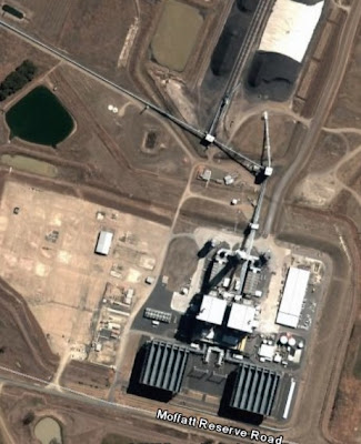
 It was, however, almost a relief (after days of 'agricultural geography' ) to come across some extractive industry when browsing the area around Millmerran where Mark overnighted today. In a small patch of higher res imagery, it was possible to pick out this open cast mine. A bit of investigation turned up the fact that this is a coal mine supplying the adjacent power station (bottom right)!
 And below a sunset 'view'....
It seems a strange place to locate a power station - so far from other industry or large consuming populations but given that coal is a bulky commodity which is expensive both literally and environmentally to transport, it doubtless makes sense to burn it as close as possible to source and to convey the electricity rather than the coal.
By my reckoning, Mark is now only 200kms from Brisbane and might well be there tomorrow. It's about 38 days since leaving Perth. It feels like it's been a long crossing! Writing this blog has certainly given me a sense of the distances which Australia entails.


No comments:
Post a Comment